Map of the Three Lands Surrounding Japan
Dai-Nihon setsujō sangoku no zenzu 大日本接壤三國之全圖
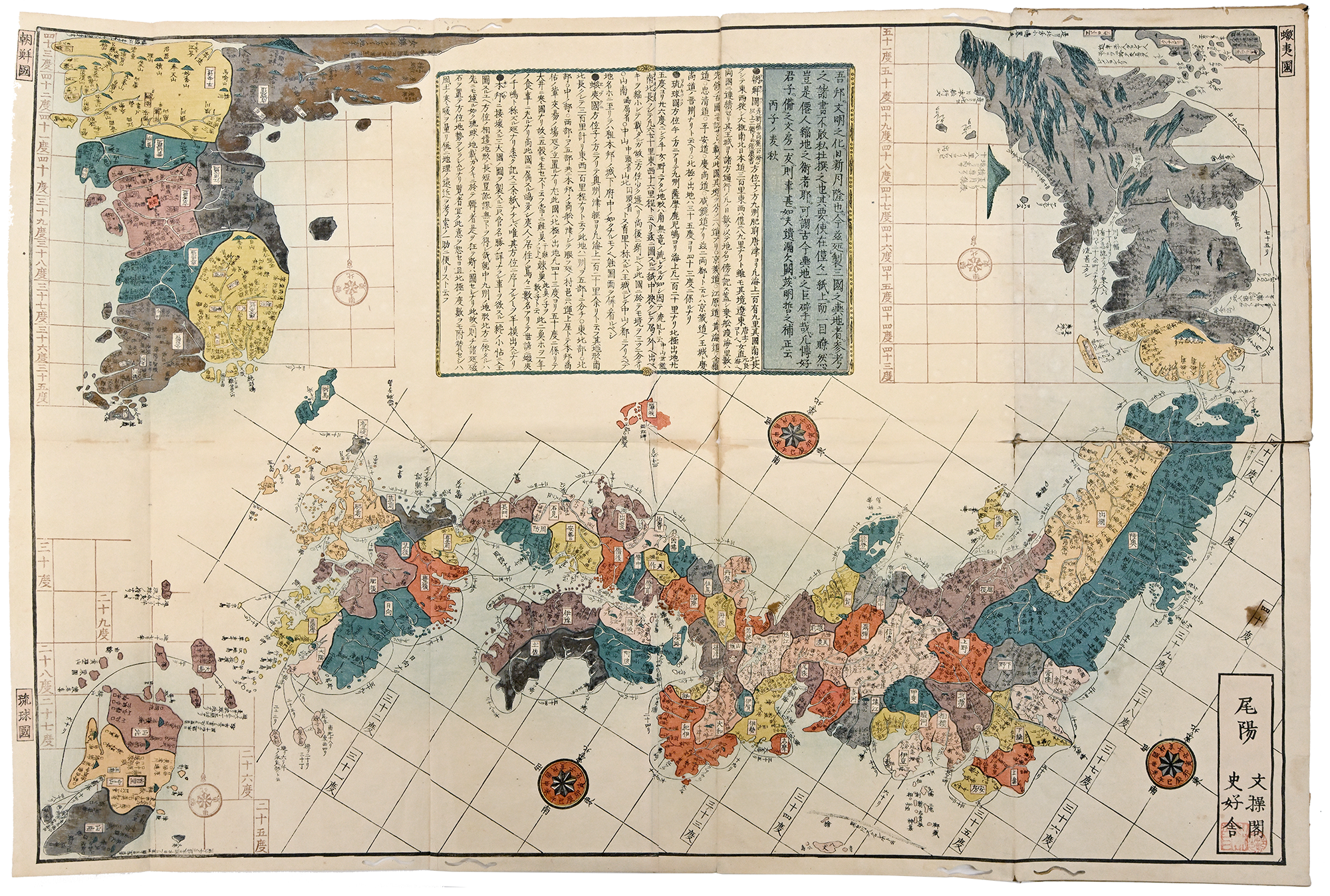
The map above (Fig. 1) is Map of the Three Lands Surrounding Japan (Dai Nihon setsujō sangoku no zenzu 大日本接壤三國之全圖), a Japanese woodblock print map from the late Tokugawa period dated to Bunka 3 (1816). The word setsujō 接壌 refers to “adjoining” or “surrounding” and sangoku 三国 to “three lands” or “three realms.” In modern Japanese, the word koku or kuni (国) generally translates into “country” in the sense of nation states; however, here, the term is more broadly applied, and refers to Ezo (present day Hokkaido), Chōsen (Chosŏn, present day Korean peninsula), and Ryūkyū (present day Okinawa).
Held by UCLA Library Special Collections, Charles E. Young Research Library as a part of the Rudolph (Richard C.) Collection of Japanese Maps, 1614-1896, this map was published by Bunsōkaku Shikōsha 文操阁 史好舍, in Biyō 尾陽 (the modern day Nagoya area). Like many others, this map belonged to the commercial map printing culture of the Tokugawa period. Given the proliferation of early modern Japan’s print culture, maps such as these were cheaper and made more often, making it easier for people to access than in earlier periods. Throughout the Tokugawa period, “maps were one of the few types of print goods for which there was a consistent and sizable audience,” and as old maps became outdated, publishers often reprinted new versions and variations.1Marcia Yonemoto, Mapping early modern Japan: Space, Place, and Culture in the Tokugawa Period, 1603-1868 (University of California Press, 2003), 16–17. Copies of this map appear in many international collections, including University of British Columbia, UC Berkeley, Tohoku University, University of the Ryukyus, and more. As a 68.58 cm × 45.72 cm folding map, the Map of the Three Lands Surrounding Japan was likely intended to be portable, meant to let the reader carry, store and use the map when needed.
The design of the map reflects how Japanese people (or at least the map’s designers or patrons) understood Japan’s borders, neighboring lands, and its position in the East Asia region. Visually, the map provides a great deal of detail to three main islands of the archipelago that were firmly within the political purview of the Tokugawa state (Honshū, Kyūshū, and Shikoku). While Ezo, Chōsen, and Ryūkyū also appear on the map, they are placed on the peripheries as related, but separate regions. The map contains many names, color divisions to distinguish between distinct areas (such as different provinces within the Japanese islands), and travel route information within both Japan and the three adjoining lands, which makes it very practical and easy to understand for the viewer. Its orientation is also different from modern day map conventions; the Japanese islands are placed horizontally with north oriented toward the upper right, northeast direction rather than vertically toward the top of the map, maximizing the view of Japan across the page layout.
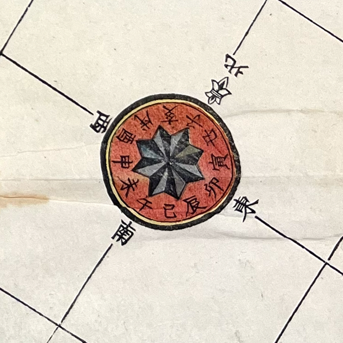
The compass featured on the map reflects the skewed directional position. The compass also uses a hyrid direcitonal system. As noted in our team's page on the Hokkaido and its Surroundings (Hokkaidō to sono shūhen 北海道とその周辺) map, earlier Japanese-style compasses were not based on the four cardinal directions, but on the Chinese zodiac system, which was used for land and marine navigation during the Edo and Meiji periods. Here we find that both systems have been overlaid, with the zodiac indicators on the inside of the compass in red and the cardinal directions on the outside of the circle.
Tokugawa maps “envisioned, created, and ultimately enshrined a new geographical, political, and social order.”2Yonemoto, 8. This helps explain why the composition of MMap of the Three Lands Surrounding Japan is important, as it shows not only the location of Japan, Ezo, Chōsen, and Ryūkyū, but also shows how these places were imagined in relation to each other. In the map, Honshū is placed in the center, while Ezo, Chōsen, and Ryūkyuū appear separate and attached around Japan.
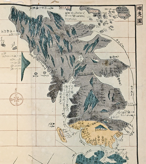
The representation of Ezo on the map is also visually different from Chōsen and Ryūkyū, filled in almost entirely with a dark grey color with the exception of the Matsumae Domain (Fig. 3). We can see the ambiguity of the Ezo region for Japanese, which had not fully incorporated the north, and for whom Matsumae (a stark contrast in yellow) is distinct from the rest of the main island. Note also that the cartographer was not certain of the actual shape of Hokkaido, an issue we discuss here.
While these three lands do not appear simply as domestic provinces, they are also not implied to be entirely independent foreign entities, and the political status of each of the “three lands” was also different. Chōsen was a foreign kingdom (a Chinese tributary) with uneasy diplomatic relations with Japan, Ryūkyū was a kingdom that had its own royal government (and was under the influence of Satsuma rulers), and the southernmost tip of Ezo was under the Matsumae Domain’s control, extending tenuous but ever-expanding influence over trade and diplomacy further and further north, to the detriment of Ainu communities.3Jun Uchida, Provincializing Empire: Ōmi Merchants in the Japanese Transpacific Diaspora (University of California Press, 2023), 49–50; Brett L. Walker, The Conquest of Ainu Lands: Ecology and Culture in Japanese Expansion, 1590–1800 (University of California Press, 2001), 178, 208. The map therefore does not fully present these three lands as equal spaces to Japan. The layout and the treatment of these areas as exterior sites of interest created a sense of Japan’s centrality, suggesting how the adjoining lands became meaningful through their position in relation to Japan. In many ways we still see a sense of a “civilized vs. barbaric” worldview that persisted during the premodern and early modern periods, in which “physical distance from the putative center determined the relative level of civilization of all places and peoples.”4Yonemoto, 3. Notably, the map presents Ezo from a Japanese cartographic perspective, not an Ainu one, despite their place as Indigenous people in the north.
As a whole, the map emphasizes “Japan and its frontiers,” and so the representation of Ezo also needs to be considered in this light. This mindset is reflected in the accompanying text on the map (Fig. 4). At the top of the map in between the depictions of Ezo and Chōsen there is a rectangular cartouche providing information on the map’s contents, including descriptions of each of the three surrounding lands. Ezo is treated as a destination and a site of ethnographic study.
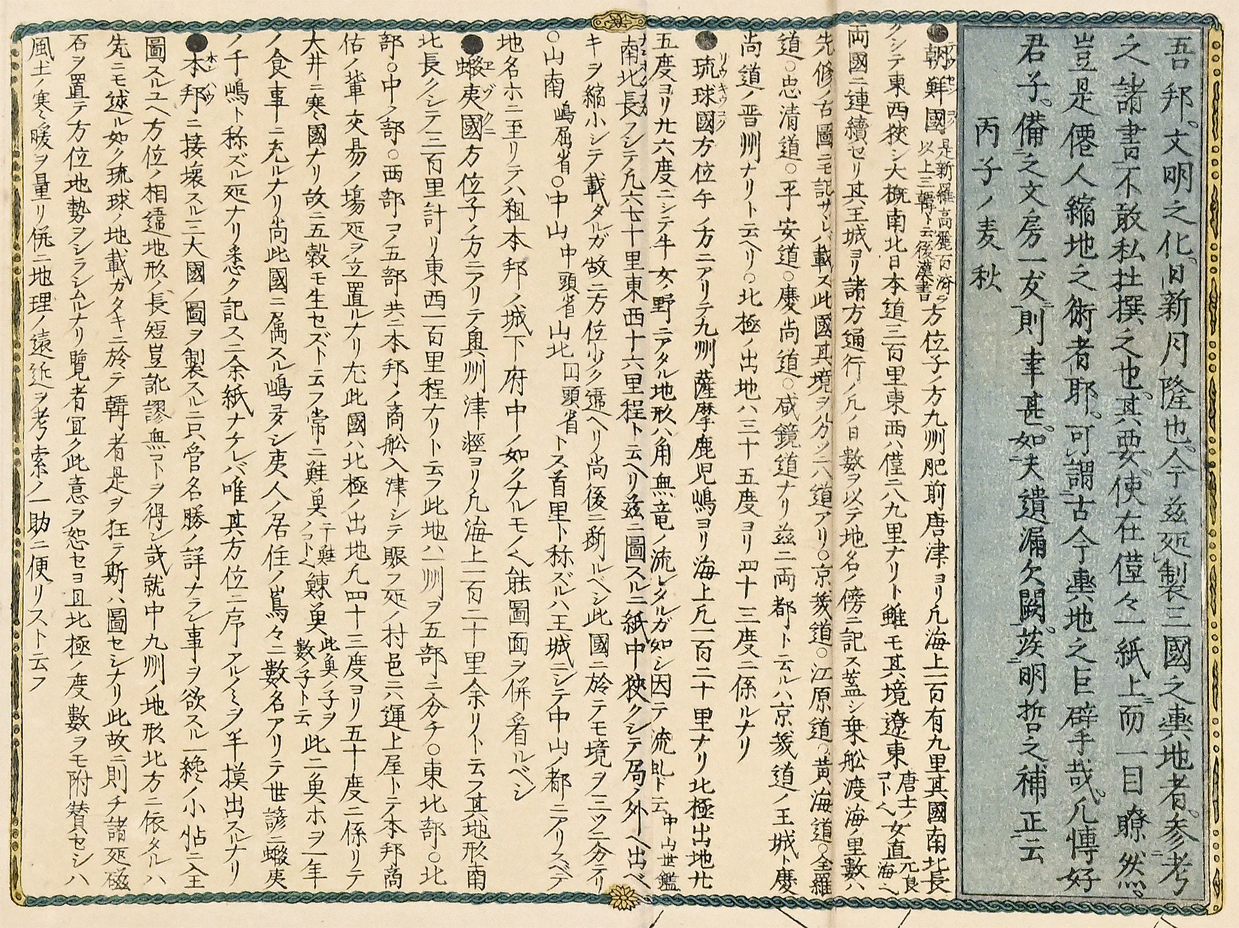
The text regarding Ezo reads:
●蝦夷国方位子ノ方ニアリテ奥州津軽ヨリ凡海上一百二十里余リト云フ其地形南北長クレテ三百里計リ東西一百里程ナリト云フ此地ハ一州ヲ五部ニ分ケ○東北部○北部○中ノ部○西部コノ五部共ニ本邦ノ商船入津シテ賑フ処ノ村邑ニハ運上屋トテ本邦商佑ノ輩交易ノ場処ヲ立置ルナリ尤此図ハ北極ノ出地凡四十三度ヨリ五十度ニ係リテ大井ニ寒国ナリ故ニ五穀モ生セズト云フ常ニ鮭魚《干鮭ノコト也》鰊魚《此魚ノ子ヲ数ノ子ト云》此二魚等ヲ一年ノ食事ニ充ルナリ尚此国ニ属スル嶋多シ夷人ノ居住ノ嶌々ニ数名アリテ世諺ニ蝦夷ノ千嶋ト称ズル処ナリ悉ク記ス二余紙ナケレバ唯其方位ニ序アルノミヲ半摸出スルナリ
This description of Ezo first provides geographic details, noting that Ezo is about 120 ri (a traditional unit of distance)5One ri = 3.9 km or 2.4 miles. by sea from Tsugaru in Ōshū, and the land of Ezo measures about 300 ri from south to north and about 100 ri from east to west. Although in the original text it says that Ezo is divided into total five parts 五部, the visible list names only four: Northeast 東北部, North 北部, Middle 中ノ部, and West 西部. Since the previous sentence also describes Ezo as “long from south to north,” the missing section may possibly be South 南部.
The description then moves from geography to trade. It says that Japanese merchant ships entered the ports of these five areas, and that in the bustling villages there are trading places called unjōya 運上屋. This detail connects the map to commercial activity between Japanese merchants and Ezo. Unjōya were connected to the basho ukeoinin 場所請負人 system, in which Matsumae domain granted Japanese merchants the right to manage trade with Ainu communities in particular trading places.6Jun Uchida, Provincializing Empire: Ōmi Merchants in the Japanese Transpacific Diaspora (University of California Press, 2023), 53–58. In this way, the written description not only describes Ezo as a distant northern land but also presents Ezo as a region tied to Japanese trade and specifically as framed by Matsumae Domain authority. The map also describes Ezo as a cold northern region (specifically citing it as between about 43 and 50 degrees north), where “even the five grains did not grow 寒国ナリ故ニ五穀モ生セズ” and where people relied on fish such as salmon, dried salmon, herring, and herring roe for food throughout the year.
This written section shows that the map was not only visual or used for navigation, but gave readers what the cartographers believed was useful information about (and a distinct impression of) Ezo through descriptions of its geography, climate, trade, and food resources. This image of Ezo presented here highlights its interpretation as a northern frontier of Japan and demonstrates how its treatment as borderland subject to Japanese authority and worldviews impacted trade, ecology, and Japanese expansion into Indigenous lands.
References
Uchida, Jun. Provincializing Empire: Ōmi Merchants in the Japanese Transpacific Diaspora. University of California Press, 2023
Walker, Brett L. The Conquest of Ainu Lands: Ecology and Culture in Japanese Expansion, 1590–1800. University of California Press, 2001
Yonemoto, Marcia. Mapping early modern Japan: Space, Place, and Culture in the Tokugawa Period, 1603–1868. Berkeley: University of California Press, 2003.