Hokkaidō and its Surroundings
Hokkaidō to sono shūen 北海道とその周辺
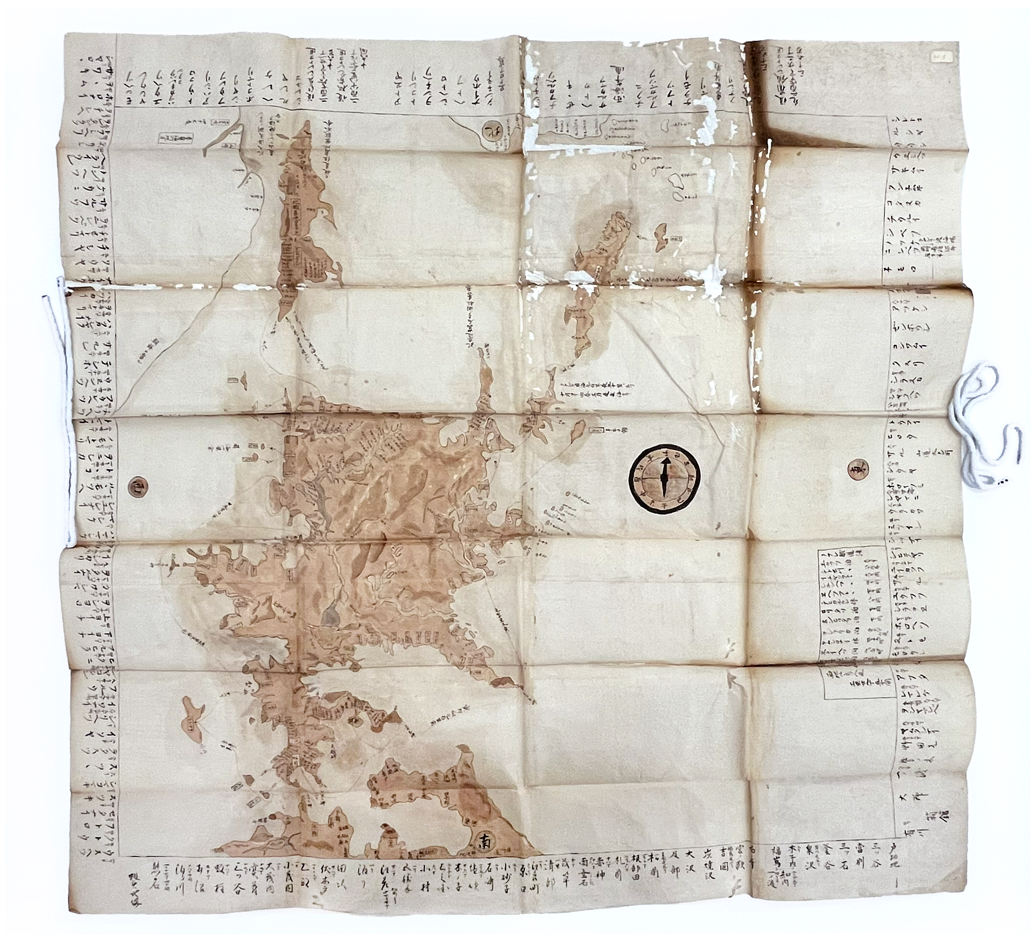
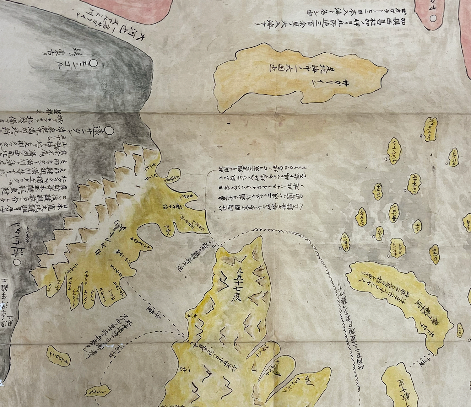
This early modern map depicts the Hokkaido region. It is a part of the Rudolph (Richard C.) Collection of Japanese Maps, 1614-1896 held by UCLA Special Collections. The information card accompanying the map lists it as “Hokkaido and its Surroundings” (Hokkaidō to sono shūhen 北海道とその周辺), but the map itself bears no title. The map is not dated and does not have an author identified. In addition to outlining the entirety of Hokkaido, the map also shows the northernmost tip of Honshu and surrounding islands as well as Sakhalin and the Kuril Islands.The map also illustrates important ports and navigational routes along the coastlines of Hokkaido, which are identified with thin lines and labels. Around the edges of the map there are various numeric notations indicating distances between specific locations and distances between the ports.
The map appears to be hand-drawn on paper rather than printed, as the hand writing is relatively natural with variations in how characters are rendered and some uneven lines. This suggests that it is likely not an official map commissioned by the government, which would be more likely to be printed and to have gone through an approval process. Based on the handwriting and style, the whole map seems to have been drawn by the same person. The map is drawn in black, brown, and red ink, with (a slightly faded) red used specifically to mark navigational routes. The size of the map is relatively large (104 cm × 101.5 cm), and can be folded when it is not being used, creating portability.
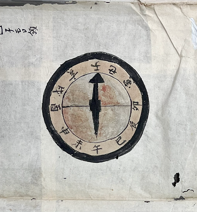
The notations on the edges of the map are done in multiple points of view (right-side up along each edge), suggesting that the map was likely spread out on large flat surfaces with people surrounding it and rotating it while reading. This, along with the overall lower quality, suggests that the map was for practical purposes like navigation, rather than ornamental or collectable purposes. The map includes a compass based not on the Western four cardinal directions, but instead on the Chinese zodiac system (Fig. 2). This system was used specifically for marine and land navigation in between Edo and Meiji periods.1Aida Nobuyuki 会田信行, “Nihon no kurinomētā no rekishi 日本のクリノメーターの歴史,” Chirigaku kyōiku to kagaku undō 地学教育と科学運動 83 (2019): 51–55.
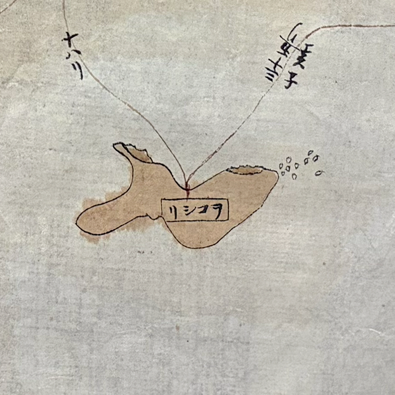
The map features the entirety of Hokkaido, the northernmost tip of Honshu (today’s Aomori Prefecture), Sakhalin, the Kuril Islands, and various smaller islands in all surrounding areas. The format in which names are given is somewhat inconsistent, with some, such as Okushiri ヲコシリ, to the west of Matsumae, labeled with characters in reverse read right to left (リシコヲ) (Fig. 2). In some cases, smaller islands have additional information appended, such as Shikotan シコタン among the southern Kuril Islands, which includes the label Nemuro ryō 子モロ領, or “Nemuro territory,” referring to the nearby peninsular region.2子モロ is hentaigana for 根室, a placename still used today.
There is a larger number of villages marked on the southern side of the map, including the southern part of the island (Matsumae) and the northern tip of Honshu. Among those villages featured throughout Hokkaido, there are many more visible on the coastlines, rather the middle of the island or its northern regions. The only inland landmarks depicted on the northern side of Hokkaido are two major rivers and the smaller tributaries branching from them. The map’s clear and exclusive emphasis on port access, the Matsumae region where most Japanese lived, and major rivers that were important access points for travel, also reaffirm that the map was primarily intended for travel and trade purposes. Given that distances along the edges of the map are mostly for navigating from and to Matsumae, we might infer that the audience for this map was either based in Matsumae or used Matsumae as a frequent stopover point for trade in or travel to the north. Either way, Matsumae is of great importance and heavily focused on.
This map has greater accuracy than some of the other maps from UCLA collections that show the Hokkaido region with significant distortions. Here, the southern part of Hokkaido, that is, around Matsumae where Japanese resided, has relatively accurate shape, ratio and size. However, the further north on the map the greater the inaccuracy, with land masses shortened north to south and appearing smaller than actual size. Sakhalin is of particular interest for evaluating the circumstances of the map’s creation and the improved accuracy of this map compared to earlier ones. In Hokkaido and its Surroundings Sakhalin is labeled as Kita Ezochi Karafuto 北蝦夷樺太, literally “Northern Barbarian Lands Karafuto.” Karafuto was the Japanese name used for Sakhalin at the time.3The label “Karafuto” for Sakhalin was used well into the twentieth century, including for Japanese-occupied southern Sakhalin. Kazutaka Unno, “Cartography in Japan,” in Cartography in the Traditional East and Southeast Asian Societies, vol. 2 of The History of Cartography, J.B. Harley and David Woodward, eds. (Chicago: University of Chicago Press, 1994), 443. The slightly truncated copy in our collections,Complete Illustration of the Land of Ezo, depicts Sakhalin as separated out into two places (Sakhalin and Karafuto respectively), the island of Sakhalin and as Karafuto, directly connected to mainland China.
Comparing the representation of Sakhalin in this map with Complete Illustration of the Land of Ezo (Ezo no kuni zenzu 蝦夷国全図) (Fig. 4), we find significant differences. The Figure 4 map is an adaptation of an original created by Hayashi Shihei 林子平 (1738–1793) in 1785. Hayashi’s original map, A Complete Illustration of General Routes Map of the Three Lands (Sangoku tsūran yoshi rotei zenzu, 三国通覧輿地路程全図), showed the three lands surrounding the Japanese archipelago (Ezo, the Ryukyus, and the Korean peninsula) along with various other islands.4Ronald P. Toby, Engaging the Other: ‘Japan’ and Its Alter Egos, 1550–1850 (Boston: Brill, 2019), 59. The slightly truncated copy in our collections, Complete Illustration of the Land of Ezo, depicts Sakhalin as separated out into two places, the island of Sakhalin and as Karafuto, with Karafuto directly connected to mainland China.
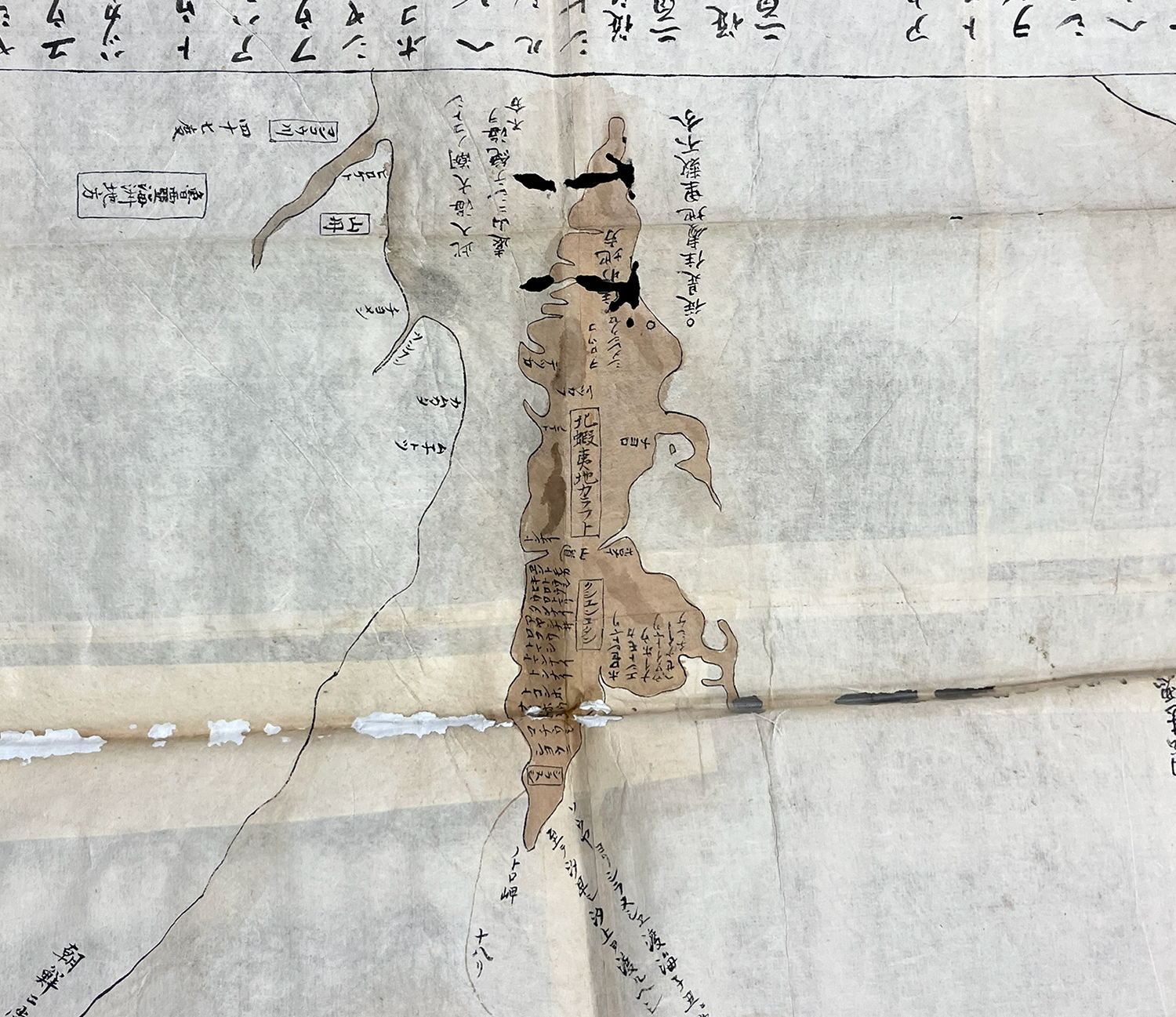
Hayashi’s separation of these sites into two locations reflects the uncertainty among Japanese at the time as to whether or not part of Sakhalin (or Hokkaido) was connected to the continent. Several expeditions from the late eighteenth century onward were responsible for correcting misconceptions of northern geography, including that of Mamiya Rinzō 間宮林蔵 (1780–1844), who conducted an independent exploration of Sakhalin in 1808–1809, where he confirmed “Karafuto” was indeed not a peninsula, and clarified previous confusions between these land masses in Japanese and European maps.5Unno, 444–450. From these differences between geographic knowledge, we can infer that our undated map Hokkaido and its Surroundings, which clearly shows Sakhalin as a separate entity, dates to after the Sakhalin expedition.
References
Aida Nobuyuki 会田信行. “Nihon no kurinomētā no rekishi 日本のクリノメーターの歴史.” Chirigaku kyōiku to kagaku undō 地学教育と科学運動 83 (2019): 51–55.
Toby, Ronald P. Engaging the Other: ‘Japan’ and Its Alter Egos, 1550–1850. Boston: Brill, 2019.
Unno, Kazutaka. “Cartography in Japan.” In Cartography in the Traditional East and Southeast Asian Societies, vol. 2 of The History of Cartography, edited by J.B. Harley and David Woodward, 346–477. Chicago: University of Chicago Press, 1994.